

ASCA Medium Sensitivity Survey
with the GIS
Y. Ishisaki^1, T. Takahashi^1,^2,
H. Kubo^1, Y. Ueda^2, K. Makishima^1
and the GIS team
^1Dept. of Physics, Univ. of Tokyo
^2Institute of Space and Astronautical Science
takahasi@astro.isas.jaxa.jp
Introduction
The study of the Cosmic X-ray Background (CXB) and the evolution of AGN is one of the major issues to be addressed by ASCA. According to the log N-log S relation obtained with Ginga, the number density of X-ray sources in the 2-10 keV energy band is expected to be 3x10^-3 arcmin^-2, if the instrument sensitivity reaches Fx (^>,~) 10^-13 erg s^-1 cm^-2. Accordingly, several deep survey projects are already going on with ASCA. However, such projects are limited both in time and sky coverage.
In order to complement these shortcomings, we have been working on the project called the "Medium Sensitivity Survey (MSS)", named after the famous work performed on the Einstein Observatory data. This utilizes all the GIS data from the PV-fields, and the GO-fields that have become publically available. The large field of view and the low-background characteristics make the GIS instrument ideal for this purpose.
The ASCA XRT PSF has large wings with significant flux extending almost over the whole field of view. However, there are a number of fields in which the target source turned out to be so dim that the outer regions of the GIS fields are essentially free from spill-over from the target source. We select out such suitable fields, mask out the target source, and utilize the remaining outer regions of the GIS fifeld of view to search for serendipitous sources (both Galactic and extra-Galactic). A clear advantage of the MSS project is its eventually large sky coverage. We have found that about thirty fields with observation time >30 ks can be used at high latitude (|b| > 10 deg), which amounts to ~ 8 deg^2 in total (the typical fraction of the remaining outer region is 60%).
Sources detected by the project will provide valuable information on the log N-log S relation over the entire 0.7-10 keV sensitivity band, which has never been available before. Also, the serendipitous fields are useful to investigate the CXB spectrum itself and the CXB fluctuation over various angular scales. If combined with optical follow-up observations, the MSS results will allow us to determine the local luminosity function of the AGN. Moreover, the results for the fields with low Galactic latitutdes will provide information on the faint Galactic sources and their contribution to the Galactic ridge X-ray emission.
The project indeed looks very promissing. However as explained below, there are several critical calibration issues which are directly related to the MSS project (Takahashi et al. and Ikebe et al., both in this issue). These include: the shape of the XRT point spread function (PSF); XRT vignetting for diffuse emission at large off-axis radii; GIS background images; and so on. The GIS team has been studying these characteristics over the full GIS field of view through various calibration opportunities, including Cyg X-1, the Crab Nebula, and 10^6-second day- and night-Earth observations.
Image Smoothing and Source Detection
Since point source images are spread to 2-3 arcmin by the point spread function (PSF) of the XRT, we must carefully smooth the images when searching for faint serendipitous sources. However a simple convolution of the image with an axisymmetric, position-independent smoothing kernel would not be optimum, since the PSF, hence the source images, depends strongly on position in the focal plane. The farther off-axis, the more distorted the PSF gets. Most noticeably, the PSF is elongated in the azimuthal direction and squeezed in the radial direction. Therefore, in the MSS project, we smooth the GIS images by cross correlating them with a position-depnendent and non-axisymmetric smoothing function which simulates the XRT PSF.
For this purpose however, the very fine details of the energy- or position-dependences of the PSF would not be necessary because the statistical error usually dominates such systematic effects. Therefore, as a "synthetic" PSF, we use a two dimensional gaussian of the form:
exp[-{
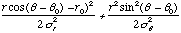 }]
(1)
}]
(1)
The parameters in the model function (Figure 1) are calculated initially from ray-traced images and then updated using the Cyg X-1 images.
In the actual procedure, we smooth each GIS image with this synthetic PSF. Then a source detection algorithm produces a list of candidate sources, which usually includes the target source itself.
Figure 1
Image Fitting
We must next evaluate the statistical significance of the candidate sources as detected above, and estimate their X-ray fluxes. This is not an easy job because the GIS background, including both non-X-ray background (NXB) and Cosmic X-ray background (CXB), is not flat across the field of view. The NXB intensity increases toward the detector rim, while the CXB intensity becomes highest on the XRT axis due to the XRT vignetting (for detail, see Kubo et al. ASCANews No.2, and Ikebe et al. this issue).
The NXB component could be eliminated relatively easily by subtracting the night-Earth image (Figure 2), which is thought to consist solely of the NXB (Tashiro et al. this issue). However, subtraction of the CXB component is much more difficult. We cannot subtract the images obtained in other deep pointings, since there would not be any genuine "source-free" field in the sky at flux levels of ~ 10^-13 erg s^-1 cm^-2. An alternative idea of modeling the CXB brightness over the GIS field of view does not work either, for two reasons. One is that the GIS image of the CXB suffers from local shadows cast by detecor window supports, which cannot be modeled with simple analytic functions. The other is that the 1 XRT vignetting for very extended diffuse emission is yet to be calibrated, especially at large off-axis radii, mainly due to uncertainty in the XRT stray light.
Therefore we have decided to utilize the day-Earth image (Figure 3) which is dominated by solar X-rays scattered off the atmosphere. Any possible non-uniformity in the X-ray brightness in each individual image will be canceled out by averaging over a large number of fields, resulting in an ideal XRT+GIS response to an extended source with a uniform brightness. Specifically, we fit each GIS image over the two dimensional field with a function as
(Night Earth) + a x {(Bright Earth) - (Night
Earth)} + b +
 (2)
(2)
where a, b, and Ai are free parameters to be determined through a two dimensional maximum likelihood fitting. The first term simply takes the NXB into account, the second term simulates the uniform CXB using the scattered solar X-rays, b is an offset, while the last term represents the candidate sources with Ai being the intensity of the i-th candidates. To be more exact, we first mask out the candidate sources and fit the remaining regions with the above model without the last term. After thus fixing the background parameters (a and b), we add point sources to the model one by one and determine their counts and errors. In order to gain statistics, we fit GIS2 and GIS3 images simultaneously, taking into account the difference in the alignment between the two telescopes.
In some cases, we have found that the diffuse emission from the target cluster gives significant contribution to the background. In that case, we limit the region of fitting such that the background can be fitted well with our model.
Figure 2
Figure 3
Example
Figure 4 shows the GIS image, selected from the MSS and smoothed in the way as described above. The candidate source list is given in Table 1. ROSAT PSPC image of the same field is shown in Figure 5 projected on the GIS detector coordinates. These two figures demonstrate how the ASCA GIS is sensitive even at large offset angles. However, we need a good PSF model to unveil faint sources. The comparison between the data and the fit in one dimensional form (Figure 6) shows that our image fitting method works very well.
When it comes to the optical identification of serendipitous sources thus detected in the MSS, the absolute accuracy of the ASCA's attitude solution, 1~2 arcmin, may not be high enough. Fortunately, however, the ROSAT PSPC data are available in the archive for most of the MSS fields so far analyzed. Through cross comparison of the GIS image with the ROSAT image, the absolute attitude accuracy of the ASCA data will be greatly improved.
| Source Position | 0.5-2 keV | 2-10 keV | ||||
|---|---|---|---|---|---|---|
| ID | DETX | DETY | counts | significance | counts | significance |
| 1 | 120.5 | 107.5 | - | - | - | - |
| 2 | 73.5 | 178.5 | 131+/-15 | 8.8[[sigma]] | 43+/-11 | 3.9[[sigma]] |
| 3 | 99.5 | 78.5 | 64+/-12 | 5.5[[sigma]] | 33+/-11 | 3.1[[sigma]] |
| 4 | 45.5 | 156.5 | 62+/-16 | 4.0[[sigma]] | - | - |
| 5 | 69.5 | 142.5 | 38+/-10 | 3.6[[sigma]] | - | - |
| 6 | 188.5 | 123.5 | 39+/-10 | 3.8[[sigma]] | 49+/-12 | 4.2[[sigma]] |
| 7 | 165.5 | 52.5 | 42+/-11 | 3.9[[sigma]] | - | - |
| 8 | 93.5 | 169.5 | - | - | 41+/-11 | 3.7[[sigma]] |
| 9 | 122.5 | 153.5 | - | - | 34+/-11 | 3.1[[sigma]] |
Figure 4
Figure 5
Figure 6
 Proceed to the next article
 Return to the previous article
 Select another article