Next: Outputs
Up: I/O interface
Previous: I/O interface
MAPGEN requires input from the user to determine the event data to be
mapped and the options for mapping it. The input phase is performed
through XView which allows for full screen input and runs in
a user-friendly manner. The MAPGEN windows are shown here
and the input fields are described.
 |
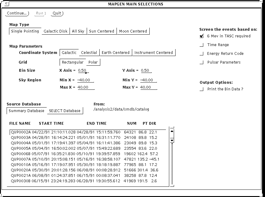
Figure 1:
Main Input Window
MAPGEN Main Window (figure
1;
larger)
- Map Type: the user has to specify the type of map
to display by clicking on one of these exclusive options.
The single pointing direction option implies a single
limited sky area covered by the instrument
while pointing at a single direction.
The galactic disk option implies that the map covers the entire galaxy
disk (-180,180 & -20,20 degrees).
The all sky option refers to the entire sky while the sun and moon
centered options imply that the map is centered on these objects.
Note that each of these options affect some of the Map Parameters values.
- Coordinate System: the user specifies whether the map should
be in galactic, celestial, earth centered or instrument centered coordinates
provided a single pointing map is chosen (other map types disable this option).
The event records have coordinates in each of these coordinate systems.
- Grid: a single pointing map may either be made on a rectangular
or polar grid (other map type all use the rectangular grid). The grid type
determines how the sky region must be entered: 4 corners for a rectangular
map or center and radius for a polar map.
- Bin Size: the bin size determines the unit area for
binning the map and may be specified on both the X and Y axis.
For rectangular maps, the X and Y bin size are fixed. The program forces
the number of bins on both axis to be even by dropping the last bin
if needed.
- Sky Region: for single pointing
plots, the user specifies the area of the sky to map in either rectangular
or polar coordinates. Though the bin center convention is used in the output
FITS maps, the user enters here the minimum and maximum points of the
rectangular map.
Only those events in the specified region will be selected.
The bin data is stored in a 3-dimensional variable size array,
BINDAT(NAXIS1,NAXIS2,NAXIS3) where NAXIS1*NAXIS2*NAXIS3 must be
less or equal to 648000 (this number is obtained for 10 levels of
a 360 by 180 map). So for less energy levels, maps with greater number
of bins can be generated.
- Source Database: the user selects events from the SMDB or SELECT
database. The program displays the appropriate list of input files taken
from the SMDB or SELECT catalog and the user simply clicks on the input file
wanted.
- Event Screening: the user may screen the events further by
requiring that they have the 6 Mev in TASC flag, narrowing the input file
time range, selecting values for the energy return codes and choosing
pulsar parameter ranges for the data. Additional input windows (not shown)
will be displayed when some of these options are selected.
- Print Option: the bin data collected may optionally be written
on the mapgen report file with this option.
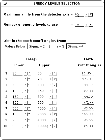
Figure 2:
Energy Selection Window
 |
Energy Selection Window (figure
2;
larger)
Upon pressing the 'Continue...' button - which is required to run the program -
a pop-up window appears and allows selection of the different energy levels
for the map as well as other parameters.
- Maximum angle from detector axis: This input is used to cut off
events beyond a specified opening angle from the detector axis.
The detector axis is obtained from the
pointing direction in the timeline file.
- Number of energy levels: the number of energy levels wanted
is selected here. This input is used to read the energy values below.
- Method for earth cutoff angles: the earth cutoff angles
must be computed by the program from a given sigma value or else
read from the screen. This option determines what method to use and
which sigma value (if any). If the user selects 'Values Below', then
the corresponding values must be provided below.
- Energy levels: Up to 10 energy levels may be used to bin
the events and only the number entered above will be used. The user enters
the lower values only (except for level 10) and the previous upper value
is adjusted. If n levels are chosen (n<10) then the nth upper range is
set by the lower value of the n+1st range.
- Earth cutoff angles: for each energy level, the
associated earth cutoff angle determines the angle to screen the events
for the earth limb effect. The values are read from the window only if
required above.
Next: Outputs
Up: I/O interface
Previous: I/O interface
CGRO SSC
1998-06-29