For Educators
Take Me to Your Data!
Note: This was written before RXTE was decomissioned. We still provide data sets to use for these lessons, even though we no longer have live data.
You are now connected to our data site! From here we can look at the most recent satellite data, which we call "Real Time" data, or tap into the bank of data that contains all the observations made from the beginning of the mission until now. This is called "Definitive" data.


 The data is continuously beamed down from the satellite and our data
archives are updated every three hours!
The data is continuously beamed down from the satellite and our data
archives are updated every three hours!
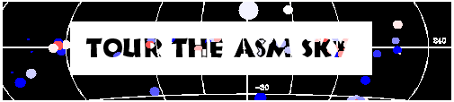
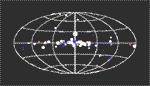
The data is presented in several ways. You can access our List O' Sources if you've already been here before or if you have a particular source you want to check out. Or you can look at our X-ray Weather Map! The Weather Map is a map of the sky that shows all the X-ray sources as well as their intensity as observed by the ASM. By clicking on different quadrants on the Weather Map, you can look at information about the sources contained in that quadrant. The Real Time and Definitive data can be accessed from both the Weather Map and the List O' Sources.
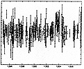
The data are represented in the form of light curves, which are graphs of X-ray Intensity versus Time. We also have a place to access the actual ASCII data so you can graph it and make your own light curves!
So, choose your tool and explore the universe! Don't worry about getting lost in space.
 Just click the "Back" button to return to Earth.
Have Fun!
 |
 List O' Sources |
 Welcome |
 Getting Started |
 Lesson Plans |
 Take Me To Your Data |