

GIS Background and Data Selection Criteria
Last updated February 20, 1997Characteristics of the GIS Background
GIS intrinsic (particle) background is known to vary with orbital positions of the satellite. Also, there are temporal particle events which should be excluded in data analysis. There are three measures to get to know the GIS intrinsic background and to select good time intervals with:.- geomagnetic cut-off rigidity (COR) on the orbit,
- Radiation Belt Monitor (RBM) counting rates, and
- GIS monitor counting rates.
Radiation Belt Monitor (RBM) is a small PIN diode detector attached to the bottom of GIS2. RBM is sensitive to particle background and used to automatically reduce high-voltage of the GIS sensors on-board.
GIS monitor counts (see http://heasarc.gsfc.nasa.gov/docs/asca/monitor.html) are house keeping parameters to count all the events (X-rays or particles) which hit the GIS pulse-height lower discriminator. Among the six GIS monitor counts for each sensor, H0 and H2 are considered to include very few X-rays and hence become good particle monitors. Below, sum of the G2_H0, G2_H2, G3_H0 and G3_H2 monitor count rates is referred to as 'H02'.
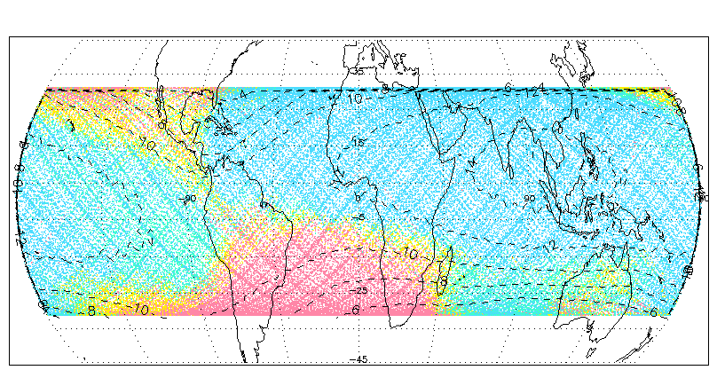
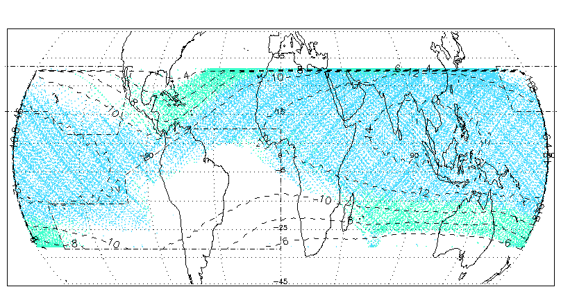
Above diagram shows distribution of the RBM counts on the ASCA orbit. Contours for the COR are also shown. The data are 59 blank sky observations carried out from June 1993 to August 1994. Red:>100 cts/s, Yellow: 18.75-100 cts/s, Green:6.25-18.75 cts/s, and Blue:<6.25 cts/s.
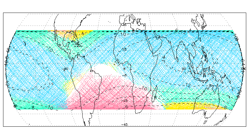
Above diagram shows distribution of the H02 counts on the ASCA orbit for the same data. The red indicates the positions where the RBM flag is on, hence GIS high-voltage is turned down automatically. Yellow: > 45.0 cts/s, Green:25.0-45.0 cts/s, and Blue:<25.0 cts/s. The blank region near Brazil is where GIS high-voltage is reduced by routine commands (hence no GIS data). It is seen that there is a good correlation between the COR and H02.
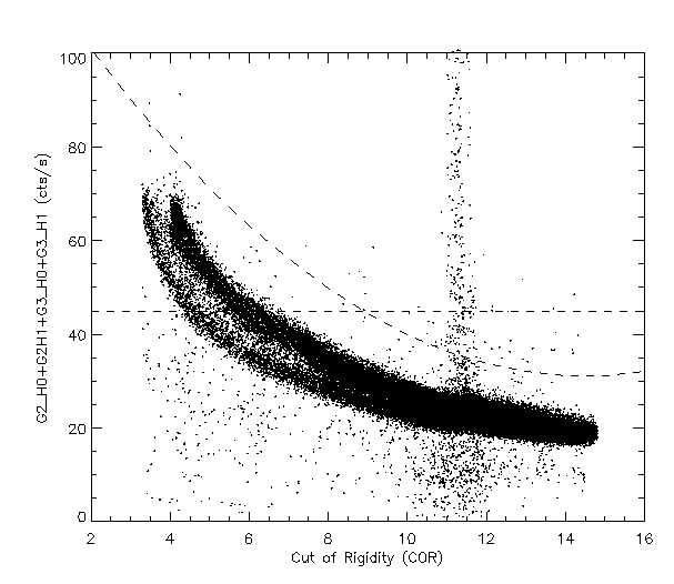
The diagram below shows the correlation between the COR and H02 for the same blank sky data. Besides the good anti-correlation, there are events having significantly high H02 values at around COR = 11-12. These are temporal particle events to be rejected in data analysis. These flare-like events turned out to have hard energy spectra, so they may be called 'hard flares'. The hard-flare events, as well as the high background regions with high H02 and low COR values, can be easily rejected by throwing away data above the two broken line, H02=45.0 and H02= 0.45 * COR^2 -13* COR +125, in the diagram.
The bifurcate below COR=8 may be due to inaccuracy of the COR map we are using in the ASCA mission. On the lower branch, which corresponds to the low COR region at around east of Florida (see diagrams below), the H02 values are not as high as on the upper branch, in spite of the low COR values.
In addition, another kind of temporal particle events, named 'soft flares', is found. The soft-flares have soft energy spectra and accompany increases of the RBM counts, but not H02. Hence they can be rejected using RBM criteria. It is found that there are two orbital regions where the soft-flares occur preferentially (regions surrounded by broken-dot lines in the diagrams below). The RBM criteria should be stricter in these regions. The suggested and conservative criteria to reject 'soft-flare' events are RBM < 18.75 cts/s everywhere and RBM < 6.25 cts/s in these two regions.
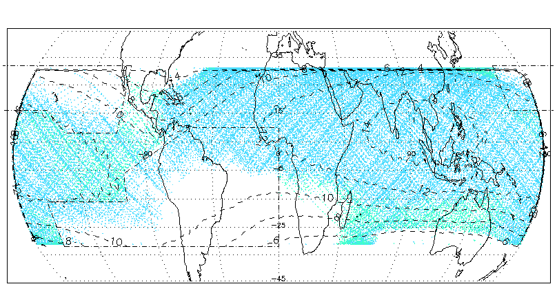
The diagram below shows the RBM count distribution after all the three screening criteria (H02 < 45 cts/s, hard-flare cut and soft-flare cut) are applied. Green:6.25-18.75 cts/s and Blue:<6.25 cts/s.
The diagram below shows the H02 count distribution after the same screening criteria are applied. Green:25.0-45.0 cts/s, and Blue:<25.0 cts/s.
GIS data selection criteria
ASCA data analysts can apply their own data selection to the GIS data by combining filter file (mkf file) parameters. ASCA GOF recommends the following criteria for loose, standard and strict GIS data selections. In the new ascascreen, which shall be released with the next ftools release (April 1997), users will be able to choose one of the following criteria as well as manual data selection.
Loose criterion:
ACS==0 && ANG_DIST > 0 && ANG_DIST < 0.01 && ELV > 5 && G2_L1 > 0 && G3_L1 > 0This criterion does not exclude GIS data based on background conditions. This will make almost all the GIS data available, and shall be used only for bright sources. The first three items exclude data with unstable pointing directions and/or large deviations. The ELV criterion excludes the data close to the earth rim; the ELV lower threshold may be tightened or loosened according to user's need. GIS X-ray events are included in G2_L1 and G3_L1, so they must be positive as long as observation is going normally.
SAA==0 && COR > 4 && (G2_H0+G2_H2+G3_H0+G3_H2)<45 && (G2_H0+G2_H2+G3_H0+G3_H2)<0.45*COR**2-13*COR+125 && RBM_CONT <100
The first two items exclude regions with high particle background on the orbit
(South Atlantic Anomaly and low COR region). The third and fourth items rejects
the high background data and the hard-flares respectively.
The last RBM_CONT criterion excludes the strong soft-flares.
This is the standard criterion which shall be used in the REV2 processing.
(RBM_CONT < 6.25 || (RBM_CONT <18.75 && !((SAT_LON > 200 && SAT_LAT < -16) || (SAT_LON > 255 && SAT_LAT < 10 && (SAT_LAT<0.36*SAT_LON-97))|| (SAT_LON<250&&SAT_LON>160&& SAT_LAT>16)||(SAT_LAT>8&&SAT_LON<250&&SAT_LAT>-0.53*SAT_LON+123))))
The soft-flare rejection criterion is tightened by applying orbital-dependent RBM_CONT
thresholds as explained in the section above.
Note that this criterion can reduce the available time significantly as a trade-off
of choosing only low background data.
Standard criterion:
In addition to the loose criterion,
Strict criterion:
In stead of the RBM_CONT < 100 in the standard criterion,
References:
If you have any questions concerning ASCA, visit
our Feedback form.