

New point-source removed GIS blank sky event files
last updated October 25, 1999
ASCA GOF releases the point-source removed GIS blank sky event database. Using the accompanying mkgisbgd ftool, which takes account of the effect of masking point sources (exposure correction), users may extract source-free blank sky spectra and images from these event files. This blank sky event database will be useful for spectrum and image analysis of dim and extended sources, for which background subtraction is of importance and taking simultaneous background in the same GIS FOV is hardly possible.
For this database, GIS high latitude observations taken between 1993 June and 1995 December are used. Total exposure time is approximately 2.1 Msec. The 'mask files', which mask point-like sources brighter than ~2e-13 erg/s/cm2 in 2-10 keV, have been supplied by Yoshitaka Ishisaki (Tokyo Metropolitan University, ishisaki@phys.metro-u.ac.jp). Please see Y. Ishisaki's doctoral thesis entitled "Spectra and Large-scale Isotropy of the Cosmic X-ray Background from ASCA Observations" for details.
The current database will supersede the old GIS blank sky database, for which point sources are not excluded and the total exposure time is shorter (~350 ksec).
These blank sky event lists are 'screened' with the standard criterion used in the ASCA REV2 pipe-line processing. Namely, event files having the '.evt' suffix are taken from the 'screened' directory in the ASCA archives, and subsequently point-sources are removed using the 'fmaskfilt' ftool with the mask files. The 'mask' image files are prepended to the source-removed event files as the primary image.
The REV2 standard screening criterion is the same as the 'ascascreen' standard criterion. Therefore, most users who adopt the standard screening criterion will not need further screening of the event files. For the users who use the ascascreen 'strict' criterion, we also made a good time interval file which corresponds to this criterion (available in CALDB; see below). Please find the GIS Background and Data Selection Criteria page for the GIS data screening criteria.
To use these source-removed event files, the effective exposure time for each pixel has to be calculated taking account of the effect of masking the point sources. This is done in the mkgisbgd ftool. Algorithm of the exposure time calculation is given in the article "Method of GIS Background Subtraction", Ikebe et al., ASCA Newsletter number 3.
For most GIS data analysis of dim sources, data quality is mainly limited by photon statistics rather than systematics. In such a case, combination of the "standard" screening of the source observation and use of the present source-removed blank sky database will provide the optimal solution of maximizing the available exposure time as well as reproducing the precise enough background. In case that your observation is long enough not to be limited by photon statistics and you believe the ultimate preciseness of the non X-ray background subtraction is required, you would need the "strict" data screening criterion and more precise background production method. However, please be warned that the "strict" criterion will significantly reduce the available exposure time. See the article "Reproducibility of the GIS Non X-ray Background " by Ishisaki et al. in ASCA Newsletter vol. 5 for details.
How to obtain the new GIS blank sky event files
They locate at HEASARC calibration database, at ftp://heasarc.gsfc.nasa.gov/caldb/data/asca/gis/bcf/bgd/no_sources. Users may obtain these files through anonymous ftp. In the same directory, besides these event files (*evt), there are the following support files:mkgisbgd, powered by the new cfitsio feature, may read remote files through network. Therefore, if you have a good network access, you may use these remote files at HEASARC, running mkgisbgd locally. In that case, you may obtain only g2file_list and g3file_list to use for mkgisbgd.
How to obtain mkgisbgd
You may download the mkgisbgd executable binaries on major platforms from http://heasarc.gsfc.nasa.gov/ftools/ftools_update.html. The source code is also available.How to create a blank sky image/spectrum using mkgisbgd
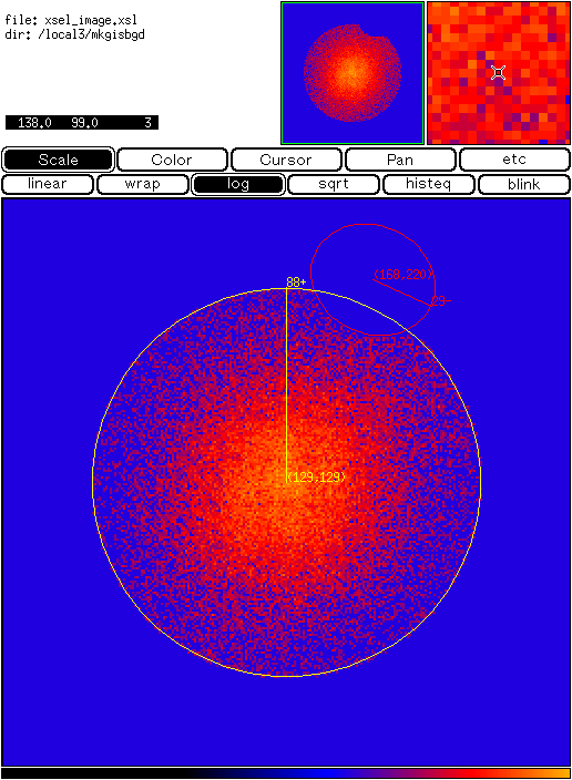
In this example, we take the Coma cluster observation (sequence number 80016000, performed on June 14, 1993), make a GIS2 spectrum, and create the corresponding sky background data with mkgisbgd.First, you should extract GIS spectrum in xselect as usual. Note that you MUST specify the selection region, even if you are going to use the entire GIS FOV. This is because the selected detector region is recorded as the WMAP (primary header) of the spectral file, and also the selected area is written in the BACKSCAL keyword in the spectral extension header.
Now we have the coma_g2.spec file. The following detector image shows an example of the region we selected.
Let's run mkgisbgd, and create the background file coma_g2.bgd:
     mkgisbgd
     Name of the GIS blank sky event file list[g2file_list]
     Input event file list exists
     Name of the input spectral file[coma_g2.spec]
     Name of the optional GTI file[NONE]
     Name of the output GIS BGD file[coma_g2.bgd]

     Blank sky file: bfn1_g2_no_source.evt
	  Original exposure in the file :2.7528E+04
     Total exposure after GTI selection: 2.7528E+04
		Number of events in the file:       2790
	Number of events after GTI selection:       2790
     Number of events selected in the region:       2790
     ...
     ...
     ...
     Total exposure after mask correction: 1.6594E+06
		   Total number of events:     384724
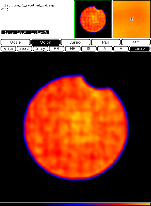
The output coma_g2.bgd file
has the primary and three extensions.
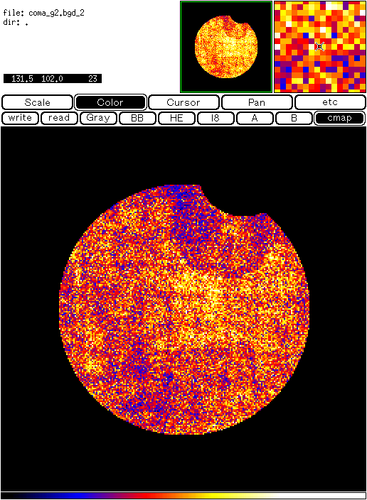
The primary image, which is shown below, is the exposure corrected
detector image. The same detector region as the WMAP of the input spectral file
is taken. Unit of the pixel is counts/pixel/sec.
You will notice that the GIS support grid structure is seen vaguely.
(The image is smoothed
with a Gaussian with the width two pixel to enhance visibility.)
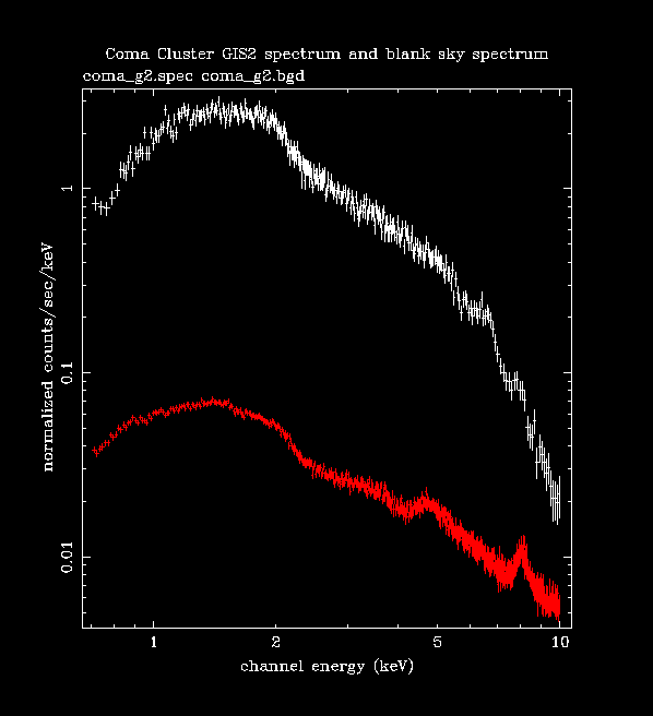
The first extension is the spectral file, which is directly used in xspec. The EXPOSURE value is correctly calculated taking into account of the effect of masking point sources. The same BACKSCAL value is copied from the input spectral file.
The source spectrum and the background spectrum are displayed together below.
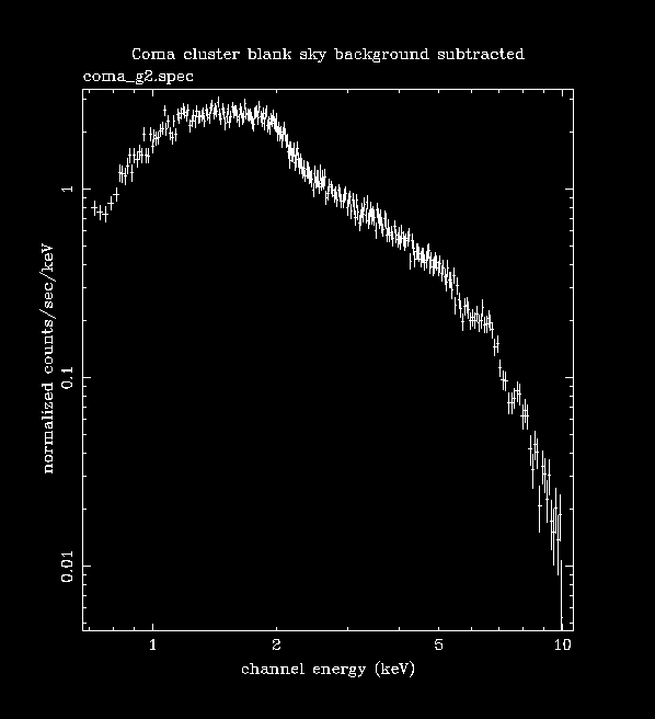
The following is the background subtracted spectrum. Note that for precise analysis of largely extended sources like Coma cluster, you would have to take into account of the scattered source photons from outside of the field of view, which we do not take into account here.
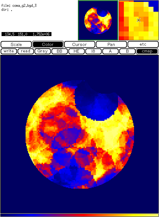
The second and third extension of the background file, which are shown below, are the exposure-uncorrected detector image and the exposure map respectively. The former has the unit counts/pixel, and the latter has seconds/pixel. The exposure corrected image in the primary is the ratio of these two images. Note that the non-uniformities of these images are due to masking point sources and superposing many blank sky fields.
If you have any questions concerning ASCA, visit our Feedback form.