|
|
WASS
The Wisconsin All-Sky Survey (WASS)
sounding rocket program was a project to map the diffuse X-ray background at
multiple bands between 0.1 and 6 keV by instruments flown on a series of
rocket flights between late 1972 and early 1980.
The two November 1973 flights were launched from Australia’s
Woomera Rocket Range. All other rocket launches were from the White
Sands Missile Range in New Mexico. The same payload was used in eight of the
flights, and a smaller version in two of the earlier flights (Dec 1972 and Nov 1973) .
|
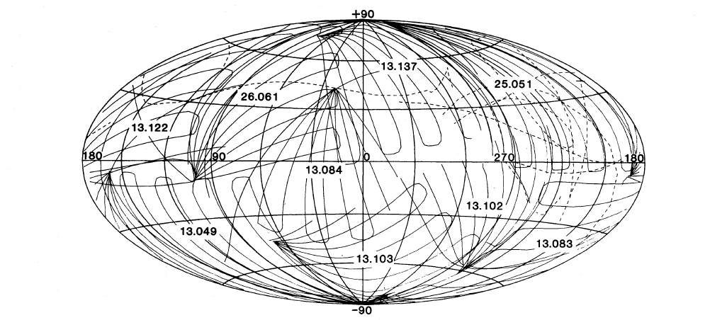 Scan paths for the rocket flights used in the survey, shown in galactic
coordinates. The path for flight 25.045 is shown as a dashed line:
This flight had a malfunctioning attitude control system.
Scan paths for the rocket flights used in the survey, shown in galactic
coordinates. The path for flight 25.045 is shown as a dashed line:
This flight had a malfunctioning attitude control system. |
| Date | Target (l,b) | Flight No | Date | Target (l,b) | Flight No |
|---|
| 8 Dec 1972 | 168.2, -9.5 | 13.083 | 1 Nov 1973 | 227.9,-56.4 | 13.103 |
| 12 Nov 1973 | 226.8,-66.6 | 13.102 | 20 Jul 1974 | 64.2,+12.8 | 13.084 |
| 8 Nov 1975 | 131.8,-29.2 | 13.049 | 15 Jan 1977 | 183.5,+15.3 | 13.122 |
| 25 May 1977 | 54.0,+41.6 | 26.061 | 6 May 1978 | 52.2,+63.7 | 13.137 |
| 15 Mar 1979 | 193.7,+50.7 | 25.045 | 21 Jan 1980 | 192.1,+41.4 | 25.051 |
Mission Characteristics
 Rocket Flights :
Special Features : Sounding Rocket Flight
Energy Range : 0.1–6 keV
Payload :
- A gas proportional counter with three-sided anticoincidence,
filled with a
90% argon/10% methane mix at ∼1 atm pressure
- Honeycomb Collimators gave a 6.5° circular field of view.
- Data collection: scanning over a fan-shaped field. Each individual flight
scanned roughly one eighth of the sky.
Science Highlights: First complete all X-ray survey of the diffuse background in seven
different X-ray band.
Archive : HEASARC hosts the WASS Maps.
[WASS Home]
[About WASS]
[Archive]
[Publications]
[All Missions]
[by Time]
[by Energy]
Page authors: Lorella Angelini Jesse Allen
HEASARC Home |
Observatories |
Archive |
Calibration |
Software |
Tools |
Students/Teachers/Public
Last modified: Thursday, 24-Sep-2020 21:33:30 EDT
|